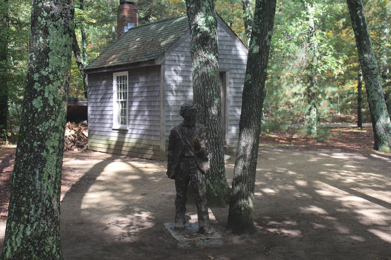
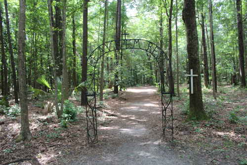
A reproduction of Thoreau's cabin and woodshed, along with a fairly life size statue of him, stand near the entrance to the Walden Pond State Reservation.
| The Cadence of Passage |
|
|
A reproduction of Thoreau's cabin and woodshed, along with a fairly life size statue of him, stand near the entrance to the Walden Pond State Reservation.
1 Comment
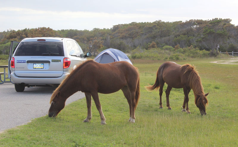
Tuesday night: For awhile during the first part of the drive to Maryland from Lancaster, I thought the weather might clear. However, it got cloudier and windier the further I drove through Delaware. Finally, by the time I reached Maryland and Assateague Island National Seashore, it was raining hard. I had a great campsite on the ocean side of the island. But I couldn’t enjoy it much because it was so windy and rainy - too windy to set up my tent. I was afraid it would blow away before I could get it up. So I spent the evening and night in the back of my minivan. I drove around the island a bit, but you can't drive too far along the Maryland side of it. I went for a walk up the flat 'boardwalk' - really just a wooden walkway - across the dunes to the ocean. It was very rough, and the wind was even stronger there. The sand hurt as it blew across my legs. I hid my face behind the hood of my jacket. There were clumps of horse manure in piles in many places along the road into the sites and along the beach. I saw five of them standing along a grassy area by the marsh where the Verrazano Bridge ends at the entrance of the road onto the island. One was all brown, and one of them was brown with white splotches - larger than spots and not really circular. From the distance, they looked smaller than the farm horses I see around Lancaster. Oddly, even though the weather was so horrible, the campsites seemed to be almost filled up with a mix of RV's and tents. The sign on the ranger station said there were vacancies, but that was earlier in the afternoon when I got here. I talked to one of my neighbors. I met him as I was walking toward the beach. He and his wife have been coming here "for years," he said, "Since the seventies. It usually completely fills up. We have to reserve a spot six months ahead," he said. He was surprised when I told him I had called and made my reservation last week. "It's the week after Labor Day and the middle of the week," I said, to explain it. He thought it had more to do with the weather. "This place fills up all year round," he said. We talked a bit. He and his wife live in Williamstown, New Jersey, which is really between Philadelphia and Atlantic City. He knew Margate. He was there not too long ago delivering things to Casels. Imagine meeting people from my home area here at the Eastern Shores of Maryland. All night the wind shook the minivan, but not enough to be frightening. The sound of it in the stunted trees and long grasses drowned out the sound of the waves. It's surprising that I couldn’t hear the ocean better given how close I was to it. That was because of the wind. Being forced to live in the back of a minivan packed with an army cot, my folded up tent, a suitcase, a cooler, a plastic box filled with stuff, and other odds and ends, is not very pleasant. The army cot is not as comfortable as my air mattress, either, but there isn't enough room in the minivan for the air mattress. I curled up on the cot and read a book. I have two wonderful LED lamps that were not expensive. If I had to live in my auto, like so many homeless people do, I would go crazy from boredom and being encased in such a small space. Wednesday: The wind shook the minivan off and on all night, and shrieked and groaned. But finally, around 3:00 a.m., the rain stopped and the clouds moved enough that I could see the full moon. It was very bright and lit up the camp ground even from behind so many clouds. The wind calmed down just before sunrise. The morning was pleasant and bright. I got out of the minivan and made breakfast: a couple of hard boiled eggs and a peach. I boiled water in a kettle on my small, portable propane gas burner and had tea. My back hurt from that army cot, but I walked around for awhile on the beach and took some photos. That helped. I pitched the tent with the help of a young woman who is in a tent with her boyfriend or husband in the site next to mine. She was walking by when I started on it. She immediately offered to help – I think she wanted to chat. I have the process of putting the tent up and breaking it down pretty much down to an art by now, but it was certainly easier with the help. We talked a bit about places we’ve camped. The two of them traveled around the country, camping, over the summer, too. I decided to drive over to the Virginia side of the island to see the Chincoteague side. On the way out, just before the Verrazano Bridge, traffic halted. A few horses were grazing along the side of the road, and another horse had tried to walk across the road, then stopped still. It must have been terrified. Cars were stopped along both sides of the road, and people got out of their vehicles to take photos. (I confess that I did, too.) Then we all took turns driving around it. I stopped off at the National Parks Service visitors’ center on the side of the bridge and told someone about the horse. She called “law enforcement” to see if they could do something before a car or human hurt it. It took a little over an hour to drive to Chincoteague National Wildlife Refuge over the small, two lane roads. I passed NASA’a Wallops Flight Facility, where they launch rockets. It’s fairly big, but not as big Houston’s site, of course. NASA scientists do a lot of research at Wallops. I drove on to the small sea side town of Chincoteague. There is a famous ice cream place there, so I stopped to try it out. There were a lot of bikers there, who sat and talked to me about the wildlife refuge. This was bikers’ week, and there were a lot of different events going around the entire area for the bikers to raise money for charities like the 9/11 fund. I drove into the wildlife refuge. The national parks pass I paid for at the entrance to Assateague Island National Seashore was also good for this. The lighthouse was not far from the entrance. I had to park in a small lot next to the road and walk a ¼ mile through a woodsy part of the barrier island to see the lighthouse. It was too steep for me to climb, especially the way my back was hurting, so I just wandered around it and took photos. It is back by the estuary behind the island, rather than on the ocean side. It is tall, but doesn’t have much else besides the actual tower and light at the top. A spiral metal staircase leads up to the very top. The lighthouse was built in 1867 and is maintained by the Coast Guard still. There is a small Coast Guard station right next to it. It once stood on the ocean side, but according to the Chincoteague Natural History Association, “Because of the dynamic movement of the island, the light no longer sits adjacent to the open sea. The southward growth of the island since 1850 has stranded the lighthouse almost 5 miles from the Chincoteague Inlet.” The organization’s website also says, “The lighthouses along the Eastern seaboard each have a unique color pattern and light flash pattern. By day, the broad red stripes over broad white stripes distinguish the Assateague Light and by night the characteristic is the flash pattern of two consecutive flashes every five seconds.” Next, I drove to the visitor’s center and watched a short film about the wild ponies and other wildlife on the island. There are a number of theories about how the horses got on the island, but the most commonly accepted one is that a Spanish ship carrying horses sank off the coast there, and some of the horses were able to swim to shore. The National Park Service’s website states: “The most plausible explanation is that they are the descendants of horses that were brought to barrier islands like Assateague in the late 17th century by mainland owners to avoid fencing laws and taxation of livestock.” However, there is now documentation that two Spanish ships were wrecked off the shores of the island. the La Galga in 1750, and a second ship thought to be the transport vessel Juno in 1802. I then drove to the end of the refuge where there was a nice, but crowded beach. I went back to the wildlife loop trail, which should have been open to vehicles but was not. I hiked a little bit along the pedestrian path which led through the marsh. Driving back to the entrance, I passed a line of cars parked along the road. People were standing on the sides of it taking photos of a band of horses out in the estuary. I stopped and took photos, too. A little way further, I again stopped to photograph a mare and her half grown colt feeding in the estuary while another horse looked on. I don’t know if that was the stallion or another mare. Then I drove back to the Maryland side of the island. On the way back, I stopped at the NASA visitors’ center. They showed a 20 minute film about the universe, then a very short film about the rockets they launch at that facility. It was very interesting. There were a lot of displays in the center related to rockets, as well as the space program. When I got back to the Maryland side of Assateague Island and the campground, I had to be careful parking in my site because there were a bunch of the horses wandering around there. Two of them walked up to the minivan and then around it, and started grazing there. I took photos of the horses who were wandering all over the various campsites. They wandered in and out all night, too. My site was popular because there is a path from a small parking lot next to the road that runs from the road, past my site, to the beach. I could hear a horse snorting nearby, occasionally, during the night. It was a bit unnerving. They look beautiful and harmless, but the park service has signs up all over warning people not to get too near because the horses bite and kick. Thursday: The next day it was terribly hot, and I desperately needed a shower. There were only two outdoor showers that were pretty disgusting, actually, and right next to the ‘vault’ toilets (fancy latrines) that I had grown pretty sick of by that time. My back was hurting a lot, too. I decided to pack up, drive around the island a little bit to see some more of it, though there wasn’t much beyond the beach and estuary on the other side of it. I was tempted to drive around the Maryland state park side, but my pass for the National Park Service maintained side didn’t cover the fee, and it was just a smaller version of the rest of the island, so I decided to leave, see some of Ocean City, which was just down the road a bit, and then head home, even though I had a reservation for one more night. One of the other campers there couldn’t get a reservation for a site for that day and would have had to check out that morning, so I let her have mine. It was already paid for, the park service wasn’t going to refund me any of it, so I figured someone should get the use of it. Ocean City, Maryland, is like most other seaside resort towns. There is the requisite amusement park, the boardwalk, the tourist junk shops, the ice cream and candy shops, the seafood restaurants, and so on. I drove around a bit, unimpressed. Frankly, I think Ocean City, New Jersey is prettier, but I admit I’m biased. I had lunch at a pizza place that offered a decent veggie burger, and then drove back to Lancaster. 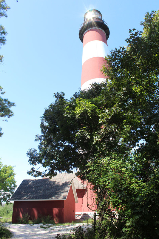
 I drove from Charleston to Carolina Beach along route 17, which is a two lane road that winds along the coastal areas though you can't see much of the coast from the road. It should have taken 3 hours and 41 minutes, according to Google Maps, but took me 5 hours because of the traffic. I had to pass through Myrtle Beach which was extremely crowded and where the worst traffic occurred. I had to go to Wilmington, NC, to get to the island, then drive down to the end of it to get to the Carolina Beach State Park where I had reservations to camp. (Yes, I finally smartened up and made reservations while I had WiFi and the Internet at the Charleston hotel.)
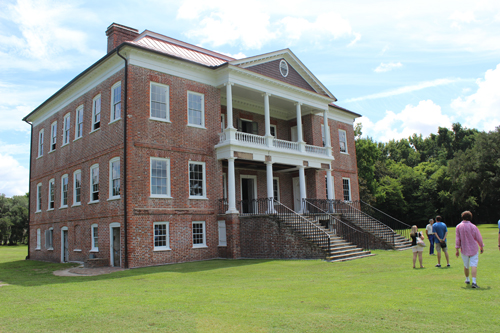
Forgive this digression, but I have come to the conclusion that public parks, such as state and national parks or other government owned sites, are the best places to camp if you are using a tent. They have strict rules about noise, alcohol, trash, and how late you can come and go in and out of the parks. They are also cheap, provide plenty of space between campsites so you have some privacy, and have rangers or some kind of park staff who drive around periodically for security. The down side is that there usually are only a few flush toilets and showers for a lot of campsites, and the showers often are kind of grungy. Sometimes there will be 'privies' instead of flush toilets - though there usually is at least one station of flush toilets and showers somewhere in the campground, and the privies are scattered through the campsites to provide more convenient service. You are also only able to burn wood that you buy from the park, or in some cases, get approved by the rangers. You are not allowed to use wood that you find on the ground or anywhere in the park. This was true of every state and national park I stayed in. In the summer, though, a camp fire is really just for effect and not necessary, especially in the South, where it is hot even at night. Still, many people like to have them. Private campgrounds tend to cram the campsites together as close as they can in order to fit as many people as they can into the area. There is little privacy and often a lot of noise. They might have rules about no noise after a certain time, but the enforcement of such rules varies, especially around holidays. People sometimes go to those campgrounds to party. Because alcohol is usually allowed at these places, the parties can get rowdy and loud. The quality of the grounds, showers, and toilets depends on the campground. Some are nice; many are not. KOA's are supposed to have staff who drive around on little golf carts at night for security, but whether or not they do so depends on the particular KOA campground. So does the quality of the grounds, toilets and showers. If you are going to stay at a private campground, make sure you do some research about it online or through AAA or the Good Sam Club. They can also get quite pricy, depending on the location. I paid as much for the KOA campground in St. Augustine as I did for a hotel room in Kansas. If you are camping in a trailer or RV of some kind, though, public campgrounds do not always have hook-ups for electricity or sewage. Here is a website that discusses this more: public vs. private camping. Anyway, I registered for my campsite at the marina along the bay side of the state park, then found the site and pitched my tent. I drove out of the park and into the town of Carolina Beach. It is a fairly typical beach town with the usual stores that sell tourist junk, others that sell ice cream (but not soft serve - it all seemed to be regular ice cream), coffee, local vegetables, and t-shirts. There were many seafood restaurants, and the requisite small amusement park with a very small roller coaster and other rides. There were some nice houses, apartment and condo buildings, but some of them were often in bad shape - it looked like they were second homes or something that just weren't taken care of, or the owners were too poor to keep them up. It was a bit odd. I found a beach access street that had parking meters on it for public parking, and walked onto the beach along a long wooden ramp over the dunes which were covered with grass and bushes in thick clumps. The beach itself did not go out far. It was a very short walk to the ocean. The sand was coarse. The ocean was very rough. It was somewhat windy, but not enough to account for such a strong surf. I supposed it was a result of the hurricane that had passed through about a week before. The water was warm, but too rough for me. I only walked a little ways in to get my feet wet and feel the temperature. The beach was fairly crowded though there were only a few people in the water. There were lifeguard stands set up intermittently along the beach. They were wooden with high sides (with ads painted on them), so it was difficult to see if there were lifeguards in them. There was one lifeguard in the one nearest to me though he looked somewhat young to be solely responsible for that area. There were no lifeguard boats that I could see, anywhere. It was too windy on the beach for me, so I went back to the car and drove around the island, looking at the various houses and shops. Then I went back to the park and my campsite, finished setting it all up, and walked along one of the trails that runs through the park. There are carnivorous plants in this park, including the Venus flytrap. The visitors' center at the entrance to the park gave a nice exhibit of the variety of plants found in the park. However, I did not see any on my walk. I returned to the campsite and lay out on my air mattress in the tent in front of my fan and read for awhile on my Kindle, which has a lit screen, as darkness settled over everything. Another plus to state and national parks is that they are usually far enough away from towns and traffic that you can see the stars through the trees, but not much else beyond other campers' lights or campfires. It gets very dark and quiet (if you don't count the sounds of insects, frogs, birds and other wildlife as noise). It is very peaceful. The next day I had breakfast at a local pancake house, called Kate's Pancake House. Kate was the greeter, sitting guests at tables. I discovered she, too, is originally from NJ - though from the north. I ate a healthy version of pancakes, drank lots of coffee, then left and drove north. I wasn't sure how far I'd get, but I wanted to make at least Richmond, VA. I thought about continuing up route 17 to Cape Hatteras and the Outer Banks, but route 17 had been horrible to drive the day before, and I decided that I was done with crowds, tourists, traffic, and heat. I wanted to go home. I drove to I-40, then connected to I-95, and kept driving. I passed Richmond early in the afternoon, realized how close I was to Washington, D.C, and then Lancaster, and kept driving. Unfortunately, I hit D.C. right around rush hour. Apparently there was also an accident somewhere on 'the beltway' as they call it there, and so it took almost four hours to get around D.C. and finally onto 695, then 83, and into P.A. At that point, though, I refused to give up and kept heading for home. I finally made it back to Lancaster. The next day I went on a tour of a local plantation. There are a number of them, some larger than others, such as the Magnolia Plantation, Boone Hall, Middleton Place, The Charleston Tea Plantation, and Drayton Hall, which is the one I went to. It is smaller than most of the others and more unique. The plantation mansion was built in the style of an English, Georgian-Palladian mansion. It is the only pre-revolutionary house still in its original condition today. The non-profit organization that has preserved it has kept it in its original condition without trying to restore it and display it in models of what people think it looked like, which is what many of the plantation homes throughout the South do. It was interesting. (I will have photos of the house and grounds in the photos section in a day or two.) The grounds also include the burial ground of former slaves and their descendants. The tour guide took us through the house, but then later also gave a presentation about slavery, its history, and its effects on the plantation and the city. He discussed Sullivan's Island, one of the beach islands near Charleston. At one point in its history, the slave ships were required to dock on this island and all sick slaves were quarantined in one of the 'Pest houses' set up to quarantine the sick. Because of the conditions on the slave ships, that meant an enormous amount of slaves were imprisoned there and died. However, it is hard to find any mention of this part of its history anywhere online. Most of the websites just discuss the island's role in protecting the city through the revolution and other wars. This site is one of the few who mention it. (See link.) In 2008, Toni Morrison donated a bench there to remind people about the role that place played in the slave trade. An organization, Bench by the Road Project, run by the Toni Morrison Society, has placed a large number of such benches in places around the South to commemorate places where the history regarding slavery and African Americans is being forgotten. That tour took most of the morning and early afternoon. I drove up to Middleton Plantation, but it was too expensive. They charged a different fee for seeing each different part of it, from the house to the gardens, as well as a fee just to enter the grounds. The heat was oppressive, so I ended up going back to the hotel and its pool.
I had to pass briefly through Alabama and Georgia to get from Florida to South Carolina. It was a short push through Alabama, which did not offer any rest areas. It was not a long ride through Georgia, either. That state does not seem that much different from Florida, along the Interstate, anyway, except that the billboards often advertise peaches for sale instead of oranges. I stopped at one small farmer’s market because it advertised on billboards almost every few miles from the welcome center all the way to exit 58, where it was. Actually, it was a bit of a disappointment. I was expecting something bigger, given all those advertisements. But it was a small house converted into a farmer’s market that sold peaches and other seasonal produce, pecans, peach slushies and ice cream made in a small machine right there, candies and other local pecan and peach sweets, peach and pecan bread, and local tourist junk, like a dried out head of a baby alligator. (Who buys that kind of thing?) I bought some peaches though I was worried they would go bad quickly in the heat of the car. They were sweet. Most of the workers there were college age kids. Some enterprising person had put big jars on the counters with signs saying “College Fund.” When I paid, the person taking my money asked me to contribute a few dollars to the college fund jar – supposedly they were all working their way through college. Who can resist an appeal like that? Then I drove on to South Carolina.
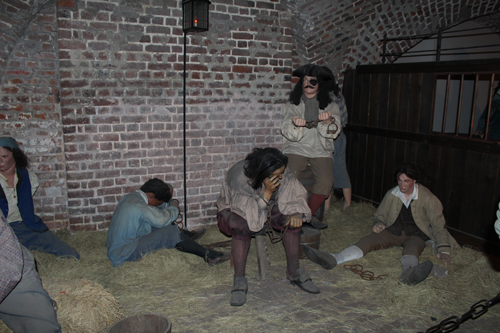
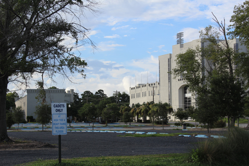
I decided that I needed a night in a hotel. There is camping on James Island State Park, which is just outside the city, but after the previous couple of nights, I wanted a real bed. The economy motels/hotels along route 17 into the city, where the cheapest hotels are to be found, were almost booked up. They also charged a lot. I ended up at a Hampton Inn and Suites, which charged as much for a room for one person as the others did (except Motel 6, which is in a league of its own, but that motel chain is the lowest of the low in more than just price). It was much nicer though. I definitely got more for more money, from a more comfortable bed, cleaner room, and free Wifi, to a nicer pool and breakfast. I decided to splurge and spend an extra night at the hotel and see more of Charleston and one of the plantations around it. Charleston is an interesting city with a long history. I drove to the historic district and parked there. Since it was a Sunday, parking was free. I was near the Old Exchange and Provost Dungeon building, so I went inside. It was close to 4:00 p.m. by then, so I got in to the last tour through the dungeon part. The guide was dressed like Blackbeard, the pirate, whom he played in various other reenactments and parades. Blackbeard is part of the history of Charleston, though he was not captured and killed there (though Charleston leaders tried). The basement of the exchange includes part of the original half-moon battery from the original wall around old Charleston. Archaeological digs turned up that part of the wall under the exchange. The tour guide showed us part of it. We saw the walls where a large amount of gun powder was hidden from the British troops during the revolution, and staged figures that illustrate where Stede Bonnet, the 'gentleman pirate' and his men were imprisoned. Then we saw a section, also with mannequins, that showed where so many of the revolutionaries had been imprisoned there while the British held the city during the revolution. It was apparently a terrible imprisonment in incredibly close confines that must have smelled horrible. After the tour, I roamed around the upper floors, seeing the old building and many of the artifacts that were on display there, from articles of clothing that dated to the colonial period, to drawings and maps of the area and buildings up through the civil war. Then the exchange closed. I wandered around the historic district looking at the old houses and buildings, including an old Huguenot church that is still in use. I also wandered along the park by the waterfront, which was very nice with fountains, green grass, park benches, and shady trees. I could see the grand Revenal bridge from there, along with the many boats using the harbor. I ate dinner at a the Griffon Pub, which had one dollar bills with names and message on them pasted all over the walls, beams, ceiling, and really anything that was a permanent surface. The bar served some good, local brews. It had a good black bean burger as an alternative for vegetarians (which I am - it is hard to get vegetarian food in the South, I have discovered.) I then drove back to the hotel, but first drove by the Citadel, which is on the other side of the city. It didn't look like much. (See photo, above.) It is the setting for Pat Conroy's book, The Lords of Discipline. I went back to the hotel and slept, soundly, in a real bed and air conditioning. 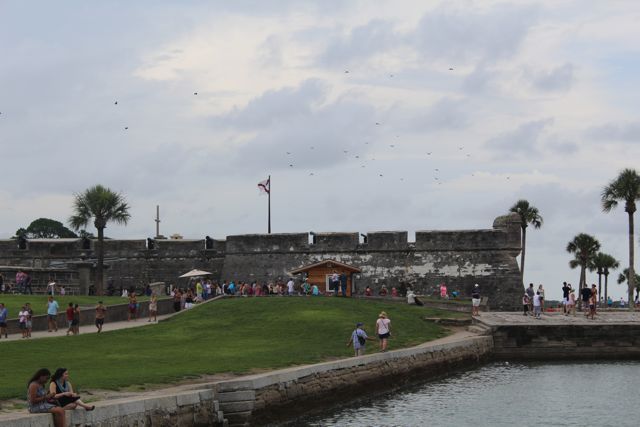 The Castillo de San Marcos at St. Augustine, Florida I searched for a place to stay on the Gulf Coast, but because it was the Fourth of July, all hotels and campgrounds that I stopped at were completely booked up. It was horribly disappointing because the original idea for this trip was that I would hang out in places along the Gulf Coast and see how people are dealing with the continuing effects of the BP oil spill. Honestly, I didn’t see anything related to the oil spill even when I was there, except a few bits of tar on the sand. Obviously, to really understand its impact, I would need to stay there and talk to people, but I wasn't going to be able to do that this weekend. To go somewhere else then go back to the Gulf Coast would use up more time and money than I had to spare. The local towns lost much of their history when Hurricane Katrina blew through, though, and that seems to have had more of an immediately obvious impact. I decided to just move on, get back on I-10, and see how far I could get into Florida.
For the record, Florida has the largest and nicest welcome center along I-10 of any state. It offered a free glass of either orange juice or grapefruit juice, and had double sets of bathrooms for both men and women. So when one bathroom for the women was closed, the other was open. This also made the lines a lot shorter when trying to get into the women's bathroom. I don't know if the men actually needed the second set of men's bathrooms, but I sure appreciated the lack of lines in the women's bathrooms! I had had to stand in long lines in the Miss. and La. [I just realized that I've been using US postal abbreviations for the states and not the AP abbreviations in past blogs.] rest area bathrooms over the best five days as people traveled for the holiday. There were a lot of vending machines, too, selling coffee and ice cream as well as the usual sodas and junk food. These things may seem small, but when you've been on the road for hours, a cup of coffee and quick bathroom stop mean a lot. I ended up in a KOA campground just a little outside of Tallahassee. It didn't have many spots left, but since I was pitching a tent and didn't need electricity or water hook-ups, I was able to get a space. Unfortunately, someone had reserved several of the small cabins the campground also offered for a Fourth of July party. The music blasted up until 10:00 p.m., but fortunately, they respected the quiet hour rules all KOAs have. The manager of the park set also set off a short but decent set of fireworks. There was a small pond in the campground, and the fireworks were set off by the pond. It was actually difficult to see the fireworks because of all the trees, but it was nice, anyway. I foolishly decided that since the city and beaches of St. Augustine were not far from the end of I-10 and where I needed to turn up north onto I-95, I would stop off for a night or two there. However, St. Augustine is a very popular place for holidays. It was very crowded. I did manage to get one of the last spots at a KOA campground just outside the city. The sites were extremely close together. I reserved my spot, then drove into the city. I had to park in the large public parking garage next to the visitors' center by the historic section. Traffic moved slowly because of all the cars. The upper level of the Castillo de San Marcos was closed because of the thunderstorms that kept rolling in. The National Park Service (NPS) was afraid of lightening strikes. The lighthouse was closed for the same reason. The rain was light, though, so I was able to walk around the historic section. Most of it was made up of stores, bars and restaurants. I ate at a Mexican restaurant and then drove back to the campground. It was getting late. I set up my tent and lay out on my thick air mattress, reading. Another thunder storm rolled through. I was grateful to discover that my tent was completely waterproof. I stayed dry. Unfortunately, two sites down, a group of people were having a party under a canopy. The rain did not deter them in the least. They blasted their stereo loudly and shouted and yelled as they played drinking games - all night. I complained to the guy who was running the office. He promised to talk to them about keeping the noise down, especially after 10:00 p.m. He told me to call the number on the sign under the pay phone by the office if they didn't tone it down after 10:00. I tried to call that number around 12:30 a.m. because the party was still going strong and loud. However, I got only the operator telling me the number was no longer in use. They finally stopped yelling and playing games around 1:20 a.m. Then some kind of family drama erupted. One of the women started screaming in Spanish to one of the men, who left in a truck with a loud engine. She then started sobbing. That went on for awhile. I wondered why this KOA didn't have anyone patrolling the grounds to make sure everything was fine, the way the other KOAs I had stayed at did. Supposedly there was someone who lived at the end of the campground and was supposed to be available for problems, but I guess that no longer valid phone number belonged to him or her. Eventually I fell asleep. I woke up around 6:00 a.m. to the sounds of the man in the tent next to mine opening and shutting doors to his truck. I was in the process of taking down my tent when the man in the tent next to mine returned from the showers. We talked for a few minutes about the party noise we had to endure all night. He was angry about it, too. He planned on staying long enough to complain to the staff in the office when it opened at 8:00 a.m. I wrote a note and left it for the office and got on the road by 7:30 a.m. Since there was no way I was going to get any more sleep, I figured I might as well get as much driving in as I could before I became too tired. But I admit, I made as much noise as possible in packing up. The other campers around me were already up, so it was only the partiers whom I was disturbing as I banged my doors. I am resolved to never stay at KOA again. I headed north to Charleston, SC. The Gulf Coast - or how the best laid plans of ... well, okay, the problem was that I didn't plan.7/7/2014 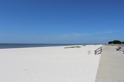 I drove from New Orleans up route 90 to Bay St. Louis, along the Gulf Coast in Mississippi. The website "Old Town Bay St. Lous" claims, "Our authentic character, historic buildings, and friendly folks are just a few of the reasons why Budget Travel Magazine named us one of the "Coolest Small Towns in America" in April 2013. And Coastal Living Magazine named Bay St. Louis one of the top ten small beach towns in the country in 2010! Explore Old Town using the menu above - or check out quick links to individual merchants below. Come play for a day, you may want to stay!" These are all seriously gross exaggerations. It is a small town of mostly modern, ranch style houses mixed with a few older ones that might qualify as 'historic,' along with a concrete walkway that lines the beaches. These are short beaches that no one seems to swim in - at least not during the day. There are some fishing boats and restaurants. I drove around the streets for a bit, but didn't see anything striking or worth stopping for. I drove on to Long Beach, which is probably almost twice as big as Bay St. Louis. It was nice, but again, nothing worth stopping for though I did stop for lunch at the Harbor View Cafe. It was in a big, old house that had been converted to a restaurant. The green salad I had was very good. I didn't realize until later, when I looked the restaurant up on the Internet, that the family that owns it used to own Ozzies in Longport, NJ! (I grew up in the next town up from Longport, NJ.) The beaches had no lifeguards and were not long or wide.
Gulfport and Biloxi run into each other. Gulfport is more of a quiet beach town geared more toward the military than tourists. There are a number of military installations there, as well as a large military retirement home there that looks out over the Gulf. There is also an air force base in Biloxi, which is a big resort town. There are many casinos there, including the big ones like the Golden Nugget and a fair number of smaller, local ones. There are also resorts, like the Jimmy Buffet's Margaritaville Casino and Restaurant. The few campgrounds in the area were really RV parks and they were all full. I managed to get a room on July 3rd at the Quality Inn for a decent price (it was a nice hotel for that kind of budget hotel). However, I could NOT get a room for the next night. In fact, everywhere I looked (though, to be fair, I didn't even try the high end resorts) the hotels and campgrounds in the entire Gulf Coast were booked solid through the 6th. To get a room for the rest of the weekend, I would need to get off the Gulf Coast and go north. I spent July 3rd walking on the beach and trying to swim in the water. The water was very warm, in the upper 80's, and completely flat - without any waves or even ripples - and also very shallow. I walked out past the end of the long fishing pier and the water was still only up to my knees. There was no real swimming possible in it. It was also very muddy - I could not see past about an inch below my knees, and my skin felt itchy and slightly burned when I first got out of the water. The sand was a fairly fine white sand, but there were patches of sargassum algae/seaweed scattered along it, as well as a fair amount of trash. The beach was not very wide. It is bordered by a concrete walkway and then the highway, which I had to cross to get to the hotel. I went back to the hotel and swam in the pool for awhile, which was cleaner and cooler. The beach had been fairly empty of people for the whole day - I made the mistake of believing the resort towns I passed through were empty of tourists because no one was using the beaches during the day as I drove through them. Oh how wrong I was. That evening people began descending on the towns. The beaches were full of people playing on the beaches and walking through or sitting in the water all evening and into the night. Some people set off firecrackers that night. I had to leave the Gulf Coast the next day in order to find somewhere else to stay, but it was nice to see that the area is actually pretty popular. I drove on to Florida and spent the Fourth of July at a KOA campground just outside the city of Tallahassee, Florida. More about that later.
New Orleans, or N’awlins as the locals say it, is an extremely beautiful, but also kind of depressing place. I had to see it during the day, which may have shaped the way I feel about it. Supposedly it comes to life with more vigor in the evening and night, but I had to catch my shuttle back to the campground at 5:45 p.m. or pay at least $30 in taxi fare.
I survived the terrible, humid heat of the night before at the campground, mainly because I sat in the air-conditioned laundry room in the campground. I have a battery operated fan that I used in the tent, which also helped. Around 10:00 p.m. it started to cool off with a nice breeze. The KOA campground was very nice – clean with lots of clean toilets and showers. There was also a clean pool, too. The sites were a little too close though – I could hear every sound the people in the tent next to me made. I slept well on my air mattress until a passing train woke me up at 6:00 a.m. with its loud whistle/horn sounds. At 9:00 a.m., one of the KOA staff members drove our small group of about five adults, two children, and several teen-agers into the city. He took a scenic route and explained things about the places we passed. Much of the River Ridge and Metaire areas we drove through were once parts of plantations. They are now very large cities, though unincorporated and considered part of New Orleans. (The campground is in River Ridge.) There are a large number of suburban areas around the city. He dropped us off by the river levee in front of the St. Louis Cathedral. We went our separate ways; I walked over to Café du Monde, a very old and world famous café. It was extremely crowded, but surprisingly there was no line. As I walked in, a couple of people had just paid their bill and were leaving their table. I took the table. I had café au lait and beignets, which taste like funnel cakes, but they are square and thick. They are delicious. A group of four African-American musicians sat in folding chairs on the sidewalk outside the covered terrace of the café and played old jazz songs with a trumpet, trombone, clarinet, and a singer. It was like something I’d seen in a movie of New Orleans. I saw groups of street musicians singing and playing throughout the city, playing all kinds of music from jazz, to reggae, rock and roll, country, and even electronic New Age music. I wandered around the French Quarter for about three hours. First I explored Jackson Square, which includes the St. Louis Cathedral, the oldest cathedral in America. It has a rich history (see the link here for more about that). There is a nice park in front of it with a fountain. On either side of it are the Presbytere and Cabildo, state museums, which look like city hall buildings for a German town. The square also includes the Pontalba Apartments, supposedly the oldest apartment buildings in the country. Now they are mostly shops and restaurants. Then I walked and walked and walked up and down the various streets, photographing the French and Spanish style buildings with their balconies, columns, tall shutters, windows and doors. I found the old Ursuline Convent buildings and St. Mary’s church, which are connected. The convent was an orphanage and school for girls in the late 1700s. Eventually it was used as a hospital, and then as a residence for bishops. Catholicism is the dominant religion in New Orleans, largely because of the Creole/Cajun history. Approximately 28% of the 90% Christian population in the state of Lousiana are Catholics, according to several different web sources (including Wikipedia, I confess, because there isn’t any current information about religion available yet in the 2010 census data). The rest are scattered into many different Protestant religions. There are at least 44 Catholic Churches in New Orleans, according to The Catholic Directory. That’s why the state is divided into parishes, instead of counties. I suppose you could consider voodoo the next dominant religion in the New Orleans area, though the voodoo shops all seem to be more tourist traps these days than anything serious. Eventually I wandered onto Bourbon Street. It’s mostly bars, jazz night clubs, sex shops, and tourist kitsch shops. Much of it seemed seedy and dingy, but I suppose at night it would all look better, especially in the light of the gas lamps that illuminate the entire quarter. Many sections of the sidewalks are covered by the porches that stretch out beyond the second and sometimes third floors of the buildings. Gas lamps often hang from the middle of these ceilings, lighting up the sidewalks and streets below them. I found Jean Lafitte’s bar. It was just a bar with a theme – the building does clearly have history (see the link here), but I’m cynical about its claims to the pirate. That street in particular seems to be so commercialized that whatever history is real is buried under the glitz and grime. I wandered back toward Jackson square, I thought, but never really made it back on my own. I passed the city’s Supreme Court building where a large press conference was about to begin. A woman standing on the steps watching the confusion of press microphones and cameras, as well as large groups of school children, explained to me that it was the 50th anniversary of the Civil Rights Act, and this press conference was one of many events going on around town. The Mayor, Mitch Landrieu, and other local leaders of the community were going to give speeches in honor of the anniversary. She pointed out that we were standing not far from the location of one of the largest of the slave auction “exchanges” in the city, where Chartres and St. Louis streets intersect. I walked over to that corner, but there was nothing there to denote its awful history. There was just a hotel there. There is an interesting essay by Richard Campanella of the Tulane School of Architecture about this absence of historical markers regarding slavery (I can't find the original article I saw, but here is another one in the link.) I continued wandering, and eventually took refuge from the heat in a small café along [ ] street, where the kind and friendly proprietor/waitress gave me a large glass of ice water before bringing me the large glass of iced tea I ordered because, she said, “You look like you need this.” I was too grateful to wonder about how pathetic I must have looked. I ate a small bowl of her specialty bread pudding even though I was too hot to be hungry. I felt like I should order something, and I was curious about what was billed as a special, local way of making the bread pudding. It was delicious with a rum and raspberry sauce. The restaurant was near where the map I got from the campground office claimed I could get a tour bus. I knew there was no way I could go on walking in this heat, and the tour busses were supposed to be air-conditioned. I could not, however, find that particular company. I did find a tourist information/tourism agency that arranges those kinds of tours. Most of the tours were all full by that time, but the man running that agency found one with room for one more. It was worth the money. The bus picked me up outside the agency and picked up other customers at different hotels and other tourism agencies. The driver was both entertaining and instructive. He took us all over the city, showing us all of the important buildings and sites. He stopped at one of the old cemeteries and took us for a walk through the streets of mausoleums, explaining the reasons why most of the dead are buried above ground like that. The extremely high water table prevents burying the dead underground unless they are in very strong, cement vaults, which some modern burial sites use. The dead “just come back up” was how our guide put it. Since most of New Orleans was Catholic, and Catholicism until fairly recently forbade cremation, the dead were buried above ground in various kinds of granite, marble or cement mausoleums or other above ground types of burials. MANY generations are often buried in the older mausoleums, from the 17th century up to the present. The ‘fresh’ body is place on top for a year and a day, then taken out and the bones are broken and put into a bag, then placed into the lower space with all of the other bones of the older dead. We piled back onto the bus and went to City Park for a 20 minute break to use the rest rooms and eat something if we wished. City Park is larger than New York’s Central Park and includes restaurants, picnic areas, a botanical garden, carousel, and much more. It is about 160 years old. Then the driver took us on a tour of the areas hit the worst by Hurricane Katrina. The city would have survived fairly well except that seven of the walls of the concrete canals collapsed. Ordinarily the canals push the water to Lake Pontchartrain then on to the Gulf. During Katrina, the opposite happened. Our guide claimed that levees held because they are built of earth covered with grass. Some of the newest canals had been built out of concrete, and those are what gave out. However, research shows that some of the levees did not hold, either. At one point the water was 13 feet high. He drove past a memorial to those who died in the storm. Half of it looks like a large red window and partial wall, which is supposed to commemorate all the houses that were destroyed, and the other half is a series of blue columns of different heights, from smallest to tallest, which represent the heights of the water at different sections of the city. We drove through various neighborhoods of the 9th and 7th wards which were hit the hardest. Many of the houses were demolished and never rebuilt. There are many lots with a concrete driveway and nothing else but weeds. There are also many houses and businesses that were never demolished but were left standing, rotting further. According to the guide, many of the homes had been passed down through families who didn’t bother getting titles or deeds because they didn’t understand the need or didn’t want to pay taxes. Consequently, they couldn’t prove they owned their homes and so couldn’t get FEMA or other government aid. However, the problems are much more complicated than that. Many people ran into serious problems with their insurance companies, among other unethical or just difficult situations. See this link for more information about that. We passed a house that still had all the markings from the search and rescue responders still scrawled on the door and front walls. The markings showed that they had found a body in that house. We passed by Fats Domino's house. According to our guide, he had been trapped in the attic but survived. Newspaper reports say he escaped to the roof and was rescued by boat from the roof. He has not renovated the house or returned to it. Next to his home is a house that he had turned into a museum dedicated to himself. That was fixed up. The house he lived in, next to the museum, however, has not been fixed up. The entire area is sad and looks something from a war torn third world country. We drove by other areas that have been fixed up. Brad Pitt established an organization called Make It Right which has re-built a small community of homes using green technology to make them sustainable and affordable. They all have solar panels on the roofs. This seemed to impress our guide the most, that the owners no longer pay electric bills, and the electric company buys back any electricity generated by their panels that they don't use. The bus driver dropped me off by the St. Louis Cathedral so I could get to the lot where our campground shuttle would pick us up. I had a little time, so I stopped into the Jackson Brewery bistro for something to eat. The entire menu was made up of seafood in the various New Orleans Cajun/Creole special style of cooking, so I ended up with just a small house salad, but a glass of good beer from the microbrewery. New Orleans is not a good place for vegetarians. That night a storm blew in quickly. It was mostly wind with very little rain. It knocked out the power in the campground several times. My tent held, though, and it cooled the air down, so I didn't mind. I decided to leave for the Gulf Coast the next day since the city was getting more crowded with Fourth of July crowds, and I didn't want to deal with larger crowds and more of the intense, humid heat.
I drove to New Orleans from Baton Rouge this morning. I stopped at the Louisiana State University's Rural Life Museum in Baton Rouge. It has a terrific indoor museum with all kinds of artifacts from the 1600's up to the past century, such as baskets, carriages, old cars, quilts, looms, steam engines, dolls, and much more. Outside it is divided up into sections. One part has reconstructed buildings from a typical 19th century plantation, including a post office, commissary, overseer's house, kitchen, slave cabins, sick house, smoke houses, blacksmith shop, sugar house, pigeon cote, and chicken house. The Folk Architecture (Upland South) has reconstructed buildings representing different cultures of Louisiana, including a split cypress barn, country church, a log house, a pioneer's cabin and outbuildings, a log house, and more. A Gulf Coast section showed Creole and Acadian structures. It was fascinating, but hot and humid.
Then I stopped off at a Cajun Village, which was really just a tourist trap of shops, and then went to the Houmas House Plantation. It was once the largest sugar plantation in America. It is huge and opulent. The part of the house that was built in the 1770s is still in very good shape, and the rest of the mansion is very beautiful. A guide, dressed in a 19th century southern belle costume, took us through the house, showing us all the many treasures it has inside. It still contains many of the paintings, furniture, etc. from the antebellum days. The owner at that time told both sides he was British and neutral, so the plantation was never occupied by troops. Our guide was very good - she told us many stories about the house and owners, as well as showed us most of the beautiful things inside the house. Then I headed on to New Orleans. I'm staying at a KOA campground tonight and tomorrow night (if I can take the heat tonight without an air conditioner). I'm only 13 miles from the historic quarter. The KOA offers a free shuttle to it. I go at 9:00 a.m. and come back at 5:00 p.m. 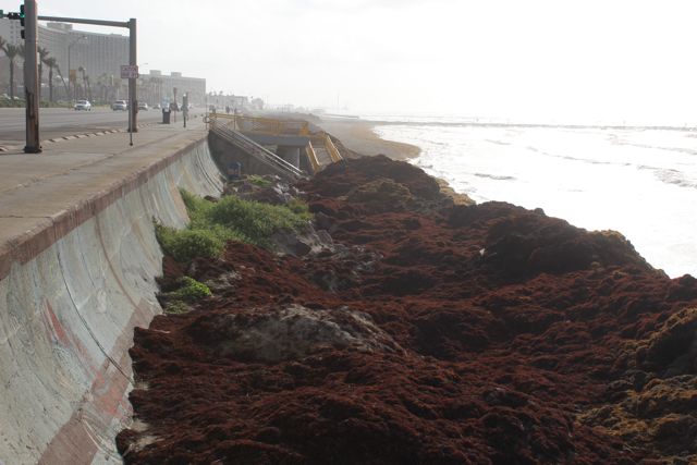 This is one of the public access beaches along the coast of Galveston. The saragassum 'seaweed' is piled all over it. I woke up early in the morning in Galveston, TX, to cool sea breezes that rapidly became inconsequential in the heat. I packed up my tent, showered, and changed in the one set of toilets/showers established for all of the campers, tents or RVs alike (why are campground showers always so grungy?), and drove around the island. The state park is on the western most end of the island. (Please read the previous blog entry for more info about where I am.) I got coffee and a slice of zucchini bread from a coffee shop in the historic district, which is really just a lot of high end shops and galleries. It was a disappointment. I had hoped to see something related to its period of piracy under Jean Lafitte or even its part in the Texas revolution, or its sordid history in slave dealing. But I didn’t see much related to Galveston's deep past. Supposedly there is a reproduction of Lafitte's house, but I couldn't find it and didn't want to spend too much time looking. Much of the island was destroyed by a hurricane in 1900, so there isn’t much of the remains of its history left. Parking is extremely difficult to find there and involves some kind of payment by phone that I didn’t want to deal with, so I drove around the harbor, which is where many large cruise ships dock. Cruise ships have become an important industry for the island. I then wandered in the Patty-wagon back to the main road that runs parallel to the beaches.
The houses are interesting. The newer houses rest on high stilts, but there are many older houses that are not. There is the Historic Pleasure Pier, an amusement park located on a wooden fishing pier that stretches into the ocean. It’s the kind that seems to be a requisite for any beach town in America wanting to attract tourists. It includes a small roller coaster. It was closed and quiet at that hour in the morning. I drove past, and headed to the eastern end of the island to see those beaches, which are larger and more preserved than the small public access beaches up and down the bulk of the island. Most of the beaches of Galveston aren’t really much of a beach. They are small strips of coarse sand (almost no sand during high tide) that this week were buried under large piles of saragassum seaweed (which is really an algae). The piles of this dark red, almost black, short seaweed looked like black dunes from a distance. They have an odd odor - like fish mixed with trash. The city has been using bulldozers to remove the large piles, but the effort seemed almost wasted. The seaweed/algae keeps washing back up with each tide. Finally, I drove to the eastern end of the island and parked in the line for the free ferry to the next island. The ferry goes to Port Bonita, which is where the cars disembark to drive along the Bolivar peninsula. It is a fairly undeveloped island/peninsula with long stretches of empty estuary, grassland with cows or horses grazing on it, beaches, and more grassland with oil wells bobbing up and down. There are some houses and even small communities with stores, bait and tackle shops, small restaurants (mostly fish) and houses, almost all built on high stilts. Eventually the island becomes a peninsula with a highway that stretches across it back to the mainland, where the road connects to the major arteries, such as I-10, which is where I ended up, driving onward toward Louisiana. I was close to the border, driving by Orange, TX, when I noticed the icon/light to check the engine was on in my dashboard. I panicked and got off at the next exit and drove to a nearby gas station. There were no mechanics there; it was strictly a place to sell gas, junk food, sodas, and other junk that tourists and truckers might get suckered into buying. A nice guy, who had been standing in line to pay for something when I asked about a mechanic, offered to look at my van. He looked at the icon/light and said that it was probably no big deal, but suggested that I go to an AutoZone to have someone connect the car to a computer and read the code to find out what precisely the problem was. He told me where to find the nearest AutoZone. I did find it, mostly by accident and good luck, and someone did connect up the computer and read the code. The fuel gauge isn’t working right. The clerk there assured me that it was no big deal as long as I kept track of how much gas I had put in the tank so I don’t run out of gas in the middle of nowhere-deep-south. He gave me the name and number of a garage/mechanic whom he recommended to fix it, but no one answered after I rang and rang the number. When I went back in to ask if someone could recommend someone else, another guy there said that mechanic was on vacation in North Dakota. He phoned someone else who came to talk to me and supposedly show me how to get to his garage. However, it turned out that the guy was the brother of the AutoZone guy. He fixes cars at his house. It felt weird, so I apologetically told him I had decided to wait and try to go for a while without fixing it. I drove on, leaving Texas behind, finally. Louisiana is very different. There are many more trees, and they are larger and more lush. At one point, between Lafayette and Baton Rouge, the interstate becomes a long string of bridges over rivers, lakes, swamps, rice fields, and more rivers. The trees stick out of some of the rivers and lakes like tiny islands onto themselves, many of them, scattered across the water. I don’t know if that is normal or a result of flooding. I drove on to the next large town, which was Lafayette, Louisiana. I tracked down a Dodge Chevrolet dealer in hopes such a place would do a professional job fixing the van. However, the dealership had so much of a backlog of business it would have been Thursday before they could get to my van. I left, discouraged, and drove to just outside of Baton Rouge. I was exhausted and hungry, so I stopped there to get a cheap motel room .and catch up on my blog entries here. Every joint and muscle in my body hurts. Traveling with fibromyalgia and osteo-arthritis is extremely difficult and grows more difficult each day. I am in constant pain, especially in my left leg, hips and back. At this point, I just want to go home. I should have done this southern part of the route first and gone back via the Midwest. It is both extremely hot and humid here now. I think I’m going to head to New Orleans, and then start making better time towards home. Trying to work with my very old laptop is becoming painful, too. It is horribly slow and not compatible with too many browsers and software now. That's why I stopped putting up photos in other sections of this website. |
AuthorSee the About page under the Home button. Archives
October 2014
|
 RSS Feed
